
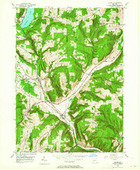
1950 Map of Alpine
USGS Topo · Published 1952About this map
Connecticut Hill and a series of high ridges define this 1950 snapshot of the southern Finger Lakes region, where the Lehigh Valley railroad dictates the flow of commerce and transit. The railway line threads through the narrow valleys, connecting the settlements of Alpine, Alpine Junction, and Cayuta. This landscape is marked by steep ravines such as Hendershot Gulf and The Gulf, while the northern edge is anchored by the waters of Lake Cayuta.
Find a feature on this map
40 named features on this map. Tap any name to fly to it.
Don’t see what you’re looking for? This feature index may not catch every label — zoom into the map to look around manually.
Map Details
Editions of this 1950 Alpine Map
2 editions found
Other maps of this area

1893 · Ithaca
USGS Topo · 1:62,500

1895 · Ithaca
USGS Topo · 1:62,500

1895 · Elmira
USGS Topo · 1:62,500

1898 · Watkins Glen
USGS Topo · 1:62,500

1901 · Watkins
USGS Topo · 1:62,500

1902 · Waverly
USGS Topo · 1:62,500

1905 · Watkins Glen
USGS Topo · 1:125,000

1949 · Ithaca West
USGS Topo · 1:24,000

1950 · Elmira
USGS Topo · 1:250,000
1950 · Burdett
USGS Topo · 1:24,000