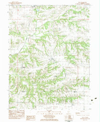
1983 Map of Alsey
USGS Topo · Published 1983About this map
Winchester and the surrounding rural townships of Roodhouse and Patterson define this section of west-central Illinois in the early 1980s. The landscape is deeply carved by the drainage systems of Sandy Creek and Little Sandy Creek, creating a complex series of ridges and valleys where small settlements like Alsey and Glasgow found their footing. The Burlington Northern railroad cuts through the terrain, serving as a primary corridor for the local agricultural economy and connecting these remote communities to larger markets.
Find a feature on this map
23 named features on this map. Tap any name to fly to it.
Don’t see what you’re looking for? This feature index may not catch every label — zoom into the map to look around manually.
Map Details
Editions of this 1983 Alsey Map
This is the sole edition of this map. No revisions or reprints were ever made.
Other maps of this area

1924 · Winchester
USGS Topo · 1:48,000

1924 · Roodhouse
USGS Topo · 1:62,500

1924 · Griggsville
USGS Topo · 1:62,500

1926 · Griggsville
USGS Topo · 1:62,500

1926 · Winchester
USGS Topo · 1:62,500

1926 · Roodhouse
USGS Topo · 1:62,500

1930 · Pearl
USGS Topo · 1:62,500

1948 · Quincy
USGS Topo · 1:250,000

1950 · Pearl
USGS Topo · 1:62,500

1956 · Quincy
USGS Topo · 1:250,000