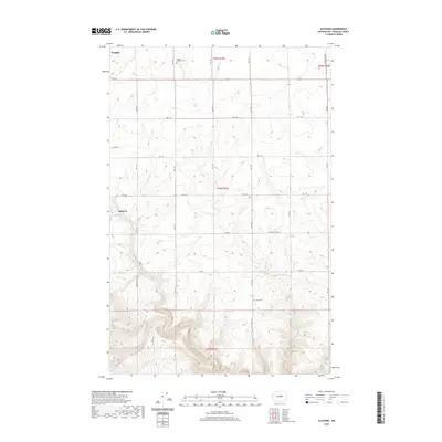
2020 Map of Alstown
USGS Topo · Published 2020About this map
The settlement of Alstown and the community of Douglas sit atop the high plateaus of Douglas County, where the landscape is defined by the deep carving of Douglas Cr. This 2020 map documents a region of large-scale agriculture and isolated rural homesteads, structured by a rigorous grid of section lines and county roads such as Supplee Rd NW and Ferrel Rd Sw. The area’s genealogical and community history is anchored by the Douglas Lutheran Cem in the north and the Slack Cem tucked near Slack Canyon Rd. The terrain transition from the flat upland grain fields to the sharp descent into the coulee provides a clear picture of how water drainage has historically dictated transportation routes like the Alstown Cutoff Rd.
Find a feature on this map
28 named features on this map. Tap any name to fly to it.
Don’t see what you’re looking for? This feature index may not catch every label — zoom into the map to look around manually.
Map Details
Editions of this 2020 Alstown Map
This is the sole edition of this map. No revisions or reprints were ever made.
Other maps of this area

1901 · Chelan
USGS Topo · 1:125,000

1912 · Malaga
USGS Topo · 1:48,000

1914 · Malaga
USGS Topo · 1:62,500

1920 · Colockum Pass
USGS Topo · 1:125,000

1922 · Colockum Pass
USGS Topo · 1:125,000

1953 · Ritzville
USGS Topo · 1:250,000

1957 · Wenatchee
USGS Topo · 1:250,000

1959 · Ritzville
USGS Topo · 1:250,000

1965 · Ritzville
USGS Topo · 1:250,000
1966 · Palisades
USGS Topo · 1:24,000