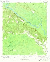
1970 Map of Altamaha SE
USGS Topo · Published 1974About this map
The Altamaha River winds through the borderlands of Tattnall, Appling, and Wayne counties, anchoring a landscape of river landings and bottomland lakes. In the early 1970s, this area remained largely rural, defined by small family cemeteries and country churches scattered across the upland ridges. Local river access is marked by Carters Bight Landing and Lower Sister Bluff Landing, points of historical transit along the water's edge.
Find a feature on this map
28 named features on this map. Tap any name to fly to it.
Don’t see what you’re looking for? This feature index may not catch every label — zoom into the map to look around manually.
Map Details
Editions of this 1970 Altamaha SE Map
This is the sole edition of this map. No revisions or reprints were ever made.
Other maps of this area

1918 · Jesup
USGS Topo · 1:62,500

1920 · Glennville
USGS Topo · 1:62,500

1943 · Jesup
USGS Topo · 1:62,500

1944 · Glennville
USGS Topo · 1:62,500

1946 · Brunswick
USGS Topo · 1:250,000

1948 · Brunswick
USGS Topo · 1:250,000

1950 · Glennville
USGS Topo · 1:62,500

1953 · Waycross
USGS Topo · 1:250,000

1956 · Brunswick
USGS Topo · 1:250,000

1958 · Waycross
USGS Topo · 1:250,000