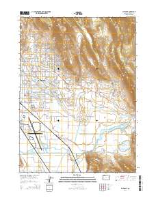
2014 Map of Altamont
USGS Topo · Published 2014About this map
Altamont serves as the primary urban center in this 2014 survey, illustrating the residential expansion and intricate irrigation network east of Klamath Falls. The landscape is defined by the managed flow of water through the A Canal, B Canal, and the Lost River Diversion Channel, which support the agricultural valley floor. To the north and east, the terrain rises sharply toward Hogback Mtn and Moyina Hill, providing a stark contrast to the level plains of the Lost River Pool. Smaller communities like Hager, Henley, and Olene anchor the outlying areas, while the Klamath Falls Airport marks the southwestern edge of the map. This study offers a detailed look at modern land use, where suburban streets like Shasta Way meet the heavy infrastructure of regional water management and transportation.
Find a feature on this map
129 named features on this map. Tap any name to fly to it.
Don’t see what you’re looking for? This feature index may not catch every label — zoom into the map to look around manually.
Map Details
Editions of this 2014 Altamont Map
This is the sole edition of this map. No revisions or reprints were ever made.
Other maps of this area

1889 · Klamath
USGS Topo · 1:250,000

1894 · Klamath
USGS Topo · 1:250,000

1955 · Klamath Falls
USGS Topo · 1:250,000

1957 · Merrill
USGS Topo · 1:62,500

1957 · Swan Lake
USGS Topo · 1:62,500

1957 · Klamath Falls
USGS Topo · 1:62,500

1957 · Modoc Point
USGS Topo · 1:62,500

1958 · Klamath Falls
USGS Topo · 1:250,000
1975 · Klamath Falls NE
USGS Topo · 1:24,000

1975 · Merrill NW
USGS Topo · 1:24,000