
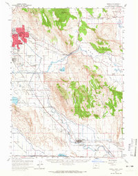
1957 Map of Merrill
USGS Topo · Published 1959About this map
Altamont and Merrill anchor this mid-century survey of the Klamath Basin, where complex irrigation networks like the Great Northern Canal and the Lost River transform the landscape between volcanic peaks. The mapping captures a period of significant local infrastructure, from the Klamath Falls Municipal Airport to several rural education centers including Ferguson School and Henley High Sch. Agricultural life is evident in the Yonna Valley and Poe Valley, supported by the Southern Pacific railroad line that moves through Malone and Dairy Siding. Significant terrain features such as Stukel Mountain and Hogback Mountain overlook the basins of Spring Lake and the marshy reaches of Lower Klamath Lake. Family historians will find interest in localized markers like the 100F Cemetery and Calvary Cemetery, as well as the community gathering point at the Grange Hall.
Find a feature on this map
52 named features on this map. Tap any name to fly to it.
Don’t see what you’re looking for? This feature index may not catch every label — zoom into the map to look around manually.
Map Details
Editions of this 1957 Merrill Map
2 editions found
Other maps of this area

1886 · Modoc Lava Bed
USGS Topo · 1:250,000

1889 · Klamath
USGS Topo · 1:250,000

1892 · Modoc Lava-Bed
USGS Topo · 1:250,000

1894 · Klamath
USGS Topo · 1:250,000

1950 · Mt. Dome
USGS Topo · 1:62,500

1950 · Dorris
USGS Topo · 1:62,500

1951 · Tulelake
USGS Topo · 1:62,500

1954 · Alturas
USGS Topo · 1:250,000

1955 · Klamath Falls
USGS Topo · 1:250,000

1957 · Swan Lake
USGS Topo · 1:62,500