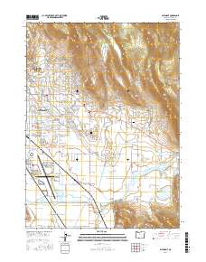
2017 Map of Altamont
USGS Topo · Published 2017About this map
The sprawling eastern edges of Klamath Falls and the community of Altamont dominate this 2017 landscape, where suburban expansion meets a complex network of high-desert irrigation. This map documents a critical intersection of water management and transportation, featuring the industrial and transit hub of the Crater Lake-Klamath Regional Airport. The terrain transitions from the residential blocks of the city into the foothills of Hogback Mtn and Moyina Hill, with the lower elevations defined by the managed flow of the Lost River and the Lost River Diversion Channel. Genealogists and local historians will find significant detail in the outlying settlements of Hager, Henley, and Pine Grove, as well as the locations of Eternal Hills Memorial Gardens Cem and Mount Calvary Cem. The intricate system of the A Canal, B Canal, and F Canal illustrates the enduring importance of water infrastructure to this Oregon region.
Find a feature on this map
128 named features on this map. Tap any name to fly to it.
Don’t see what you’re looking for? This feature index may not catch every label — zoom into the map to look around manually.
Map Details
Editions of this 2017 Altamont Map
This is the sole edition of this map. No revisions or reprints were ever made.
Other maps of this area

1889 · Klamath
USGS Topo · 1:250,000

1894 · Klamath
USGS Topo · 1:250,000

1955 · Klamath Falls
USGS Topo · 1:250,000

1957 · Merrill
USGS Topo · 1:62,500

1957 · Swan Lake
USGS Topo · 1:62,500

1957 · Klamath Falls
USGS Topo · 1:62,500

1957 · Modoc Point
USGS Topo · 1:62,500

1958 · Klamath Falls
USGS Topo · 1:250,000
1975 · Klamath Falls NE
USGS Topo · 1:24,000

1975 · Merrill NW
USGS Topo · 1:24,000