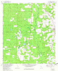
1982 Map of Altha West
USGS Topo · Published 1983About this map
The Chipola River flows through the heart of this North Florida landscape, creating a complex network of wetlands and oxbows like Horseshoe Bend and Ring Jaw Island. In the early 1980s, the area around Altha and the small settlements of Willis and Chason maintained a rural character defined by a mosaic of numerous ponds and creek branches. Of particular interest to genealogists and local historians are the many small burial grounds and rural churches that dot the terrain, including New Shiloh Cem, Old Shiloh Cem, and Gortemoller Cem. The legacy of former transport is preserved in the Old Railroad Grade running through the northeastern quadrant, while modern infrastructure is represented by a network of pipelines and a local landing strip near the Jackson and Calhoun county line.
Find a feature on this map
47 named features on this map. Tap any name to fly to it.
Don’t see what you’re looking for? This feature index may not catch every label — zoom into the map to look around manually.
Map Details
Editions of this 1982 Altha West Map
This is the sole edition of this map. No revisions or reprints were ever made.
Other maps of this area

1944 · Clarksville
USGS Topo · 1:31,680

1945 · Juniper Creek
USGS Topo · 1:31,680

1945 · Blountstown
USGS Topo · 1:31,680

1945 · Clarksville
USGS Topo · 1:31,680

1952 · Cypress
USGS Topo · 1:24,000

1952 · Oakdale
USGS Topo · 1:24,000

1952 · Kynesville
USGS Topo · 1:24,000

1952 · Alford SE
USGS Topo · 1:24,000

1952 · Altha West
USGS Topo · 1:24,000

1952 · Altha East
USGS Topo · 1:24,000