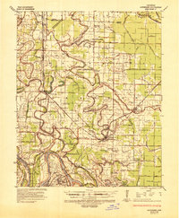
1935 Map of Altheimer
USGS Topo · Published 1944About this map
The Arkansas River defines the southern boundary of this 1930s landscape, where complex meanders like Ste Marie Bend and Kelly Bend shape the surrounding alluvial plains. This era of the Delta is characterized by a dense network of drainage canals and bayous, including Wabbaseka Bayou and Indian Bayou, which support an agricultural economy centered on settlements like Altheimer, Wabbaseka, and Sherrill. The infrastructure of the period is prominent, with the St Louis Southwestern Railway connecting small rural stops and a Penal Farm to larger markets.
Find a feature on this map
122 named features on this map. Tap any name to fly to it.
Don’t see what you’re looking for? This feature index may not catch every label — zoom into the map to look around manually.
Map Details
Editions of this 1935 Altheimer Map
2 editions found
Other maps of this area

1891 · Little Rock
USGS Topo · 1:125,000

1893 · Little Rock
USGS Topo · 1:125,000

1932 · Pastoria
USGS Topo · 1:62,500

1935 · Altheimer
USGS Topo · 1:62,500

1935 · Pastoria
USGS Topo · 1:62,500

1935 · Varner
USGS Topo · 1:62,500

1935 · Noble Lake
USGS Topo · 1:62,500

1937 · Stuttgart
USGS Topo · 1:62,500

1937 · England
USGS Topo · 1:48,000

1939 · Keo
USGS Topo · 1:31,680