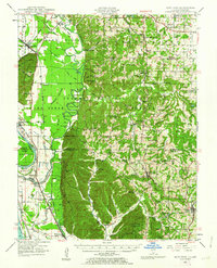
1947 Map of Alto Pass
USGS Topo · Published 1963About this map
Shawnee National Forest dominates the topography of this Southern Illinois river landscape, where the Mississippi River and the Big Muddy River converge. The terrain is marked by dramatic shifts between the fertile Oakwood Bottoms and the heights of Bald Knob, which rises sharply above the floodplains. Settlement patterns follow the rail lines, with the Illinois Central RR, Missouri Pacific RR, and Gulf Mobile and Ohio RR connecting towns like Alto Pass and Grand Tower.
Find a feature on this map
118 named features on this map. Tap any name to fly to it.
Don’t see what you’re looking for? This feature index may not catch every label — zoom into the map to look around manually.
Map Details
Editions of this 1947 Alto Pass Map
2 editions found

Other maps of this area

1910 · Herrin
USGS Topo · 1:62,500

1910 · Murphysboro
USGS Topo · 1:62,500

1916 · Campbell Hill
USGS Topo · 1:62,500

1918 · Altenburg
USGS Topo · 1:62,500

1918 · Campbell Hill
USGS Topo · 1:62,500

1920 · Jonesboro
USGS Topo · 1:62,500

1920 · Dongola
USGS Topo · 1:62,500

1922 · Carbondale
USGS Topo · 1:62,500

1922 · Cape Girardeau
USGS Topo · 1:62,500

1923 · Dongola
USGS Topo · 1:62,500