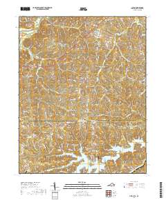
2019 Map of Alton
USGS Topo · Published 2019About this map
Turbeville and Alton anchor the northern and eastern reaches of this landscape where the Virginia North Carolina state line divides the terrain. This borderland is defined by the significant hydrological presence of Hyco Lake and the After Bay Reservoir in the south, while the Dan River flows across the northwestern corner. The area’s spiritual and communal history is well-preserved through numerous landmarks, including the Chestnut Grove Baptist Church and several family or community burial grounds such as Cunningham Cem and Olive Branch Cem.
Find a feature on this map
92 named features on this map. Tap any name to fly to it.
Don’t see what you’re looking for? This feature index may not catch every label — zoom into the map to look around manually.
Map Details
Editions of this 2019 Alton Map
This is the sole edition of this map. No revisions or reprints were ever made.
Other maps of this area

1943 · Roxboro
USGS Topo · 1:62,500

1952 · Milton
USGS Topo · 1:62,500

1953 · South Boston
USGS Topo · 1:62,500

1953 · Greensboro
USGS Topo · 1:250,000

1954 · Greensboro
USGS Topo · 1:250,000

1956 · Milton
USGS Topo · 1:62,500

1957 · South Boston
USGS Topo · 1:62,500

1962 · Greensboro
USGS Topo · 1:250,000

1966 · Greensboro
USGS Topo · 1:250,000

1968 · Leasburg
USGS Topo · 1:24,000