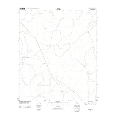
2012 Map of Altuda
USGS Topo · Published 2012About this map
The settlement of Altuda sits at a critical junction in Brewster County, where transportation routes and ranching interests meet in the high desert. This 2012 survey shows the area's ongoing reliance on established cattle operations, notably Youngs Ranch and James Ranch, which have defined the local geography for generations. These private holdings are connected by essential thoroughfares like Altuda Ranch Rd and Spicewood Ranch Rd, illustrating the sparse but interconnected settlement pattern of the Trans-Pecos region. Drainage in this arid landscape is marked by Dugout Cr, which winds through the southern portion of the quadrangle. The map provides a precise layout of the modern ranching infrastructure, capturing the enduring character of this remote West Texas community.
Find a feature on this map
6 named features on this map. Tap any name to fly to it.
Don’t see what you’re looking for? This feature index may not catch every label — zoom into the map to look around manually.
Map Details
Editions of this 2012 Altuda Map
This is the sole edition of this map. No revisions or reprints were ever made.
Other maps of this area

1895 · Alpine
USGS Topo · 1:125,000

1920 · Monument Spring
USGS Topo · 1:62,500

1921 · Monument Spring
USGS Topo · 1:62,500

1923 · Altuda
USGS Topo · 1:62,500

1954 · Fort Stockton
USGS Topo · 1:250,000

1958 · Fort Stockton
USGS Topo · 1:250,000

1972 · Bird Mountain
USGS Topo · 1:24,000

1972 · Elam Mountain
USGS Topo · 1:24,000

1973 · Fort Stockton
USGS Topo · 1:250,000
1983 · Mount Ord
USGS Topo · 1:24,000