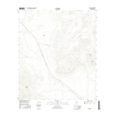
2016 Map of Altuda
USGS Topo · Published 2016About this map
The settlement of Altuda sits at the base of the Del Norte Mountains in this high-desert region of Brewster County. This area serves as a significant pass for U.S. Route 90, which cuts a path between the Del Norte Mountains to the south and the Glass Mountains to the northeast. The landscape is defined by its dramatic relief, reaching its peak at Cathedral Mtn, while seasonal drainage is marked by the winding paths of Emerson Draw and Dugout Cr. Local access is limited to a small network of ranch roads, including Altuda Ranch Rd and Spicewood Ranch Rd, which connect isolated homesteads to the primary highway corridor. The map reveals the stark geological transition where the basin floor meets the rising limestone and volcanic formations of the surrounding ranges.
Find a feature on this map
9 named features on this map. Tap any name to fly to it.
Don’t see what you’re looking for? This feature index may not catch every label — zoom into the map to look around manually.
Map Details
Editions of this 2016 Altuda Map
This is the sole edition of this map. No revisions or reprints were ever made.
Other maps of this area

1895 · Alpine
USGS Topo · 1:125,000

1920 · Monument Spring
USGS Topo · 1:62,500

1921 · Monument Spring
USGS Topo · 1:62,500

1923 · Altuda
USGS Topo · 1:62,500

1954 · Fort Stockton
USGS Topo · 1:250,000

1958 · Fort Stockton
USGS Topo · 1:250,000

1972 · Bird Mountain
USGS Topo · 1:24,000

1972 · Elam Mountain
USGS Topo · 1:24,000

1973 · Fort Stockton
USGS Topo · 1:250,000
1983 · Mount Ord
USGS Topo · 1:24,000