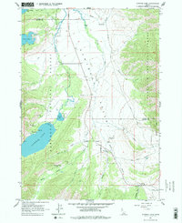
1963 Map of Alturas Lake
USGS Topo · Published 1977About this map
Sawtooth City (Site) and the nearby Sawtooth Cem serve as historical markers of early settlement within the Sawtooth National Forest. This high-altitude landscape is defined by the Sawtooth Valley and a chain of prominent alpine lakes, including Alturas Lake, Pettit Lake, and Yellow Belly Lake. The presence of Lake Alturas Lodge, Smoky Bear Lodge, and specialized facilities like Camp Perkins and Camp Luthy indicates a mid-century era focused on recreation and forestry. The Smiley Creek Landing Strip provides an essential backcountry aviation link in this remote terrain, while the winding Salmon River and its many tributaries, such as Smiley Creek and Beaver Creek, dictate the movement through the valley floors. For the local historian, the map preserves the precise location of legacy sites and campgrounds like North Shore Campground and Smoky Bear Campground before more modern developments altered the recreational footprint.
Find a feature on this map
32 named features on this map. Tap any name to fly to it.
Don’t see what you’re looking for? This feature index may not catch every label — zoom into the map to look around manually.
Map Details
Editions of this 1963 Alturas Lake Map
3 editions found

Other maps of this area

1900 · Sawtooth
USGS Topo · 1:125,000

1919 · Custer
USGS Topo · 1:125,000

1922 · Custer
USGS Topo · 1:125,000

1955 · Hailey
USGS Topo · 1:250,000

1957 · Challis
USGS Topo · 1:250,000

1959 · Hailey
USGS Topo · 1:250,000

1960 · Challis
USGS Topo · 1:250,000

1962 · Hailey
USGS Topo · 1:250,000

1963 · Challis
USGS Topo · 1:250,000

1963 · Mt Cramer
USGS Topo · 1:24,000