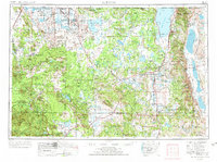
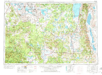
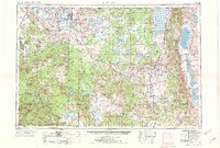
1954 Map of Alturas
USGS Topo · Published 1971About this map
The Modoc Plateau dominates this northeastern California landscape, characterized by volcanic features and expansive high-desert basins. Alturas serves as the central hub where State Highway 299 meets U.S. Highway 395, surrounded by the extensive Modoc National Forest. The map documents a complex water management system involving the Pit River, Clear Lake Reservoir, and the alkaline stretches of Goose Lake near the Oregon border.
Find a feature on this map
106 named features on this map. Tap any name to fly to it.
Don’t see what you’re looking for? This feature index may not catch every label — zoom into the map to look around manually.
Map Details
Editions of this 1954 Alturas Map
4 editions found

Other maps of this area

1886 · Alturas
USGS Topo · 1:250,000

1886 · Honey Lake
USGS Topo · 1:250,000

1886 · Lassen Peak
USGS Topo · 1:250,000

1886 · Modoc Lava Bed
USGS Topo · 1:250,000

1886 · Shasta
USGS Topo · 1:250,000

1886 · Granite Range
USGS Topo · 1:250,000

1889 · Klamath
USGS Topo · 1:250,000

1889 · Long Valley
USGS Topo · 1:250,000

1890 · Red Bluff
USGS Topo · 1:250,000

1891 · Honey Lake
USGS Topo · 1:250,000