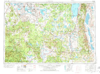
1954 Map of Alturas
USGS Topo · Published 1974About this map
Alturas serves as the regional hub in this 1970s revision, situated where the Pit River meets the western edge of the Warner Mountains. This high-desert landscape is defined by its volcanic geology and massive water bodies, including the sprawling Goose Lake on the Oregon-California border and the extensive Clear Lake Reservoir. The map illustrates a complex network of mid-century infrastructure, with the Southern Pacific, Great Northern, and Western Pacific railroads converging to move timber and livestock through the region.
Find a feature on this map
107 named features on this map. Tap any name to fly to it.
Don’t see what you’re looking for? This feature index may not catch every label — zoom into the map to look around manually.
Map Details
Editions of this 1954 Alturas Map
4 editions found

Other maps of this area

1886 · Alturas
USGS Topo · 1:250,000

1886 · Honey Lake
USGS Topo · 1:250,000

1886 · Lassen Peak
USGS Topo · 1:250,000

1886 · Modoc Lava Bed
USGS Topo · 1:250,000

1886 · Shasta
USGS Topo · 1:250,000

1886 · Granite Range
USGS Topo · 1:250,000

1889 · Klamath
USGS Topo · 1:250,000

1889 · Long Valley
USGS Topo · 1:250,000

1890 · Red Bluff
USGS Topo · 1:250,000

1891 · Honey Lake
USGS Topo · 1:250,000