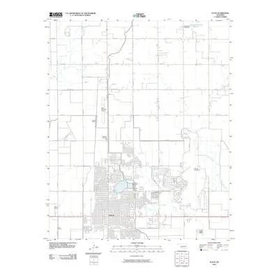
2010 Map of Altus
USGS Topo · Published 2010About this map
Altus is the central hub of this Jackson County landscape, characterized by a grid-like urban center that transitions into sprawling aviation and military infrastructure. To the east, the expansive Altus Air Force Base dominates the periphery, while multiple aviation sites including Altus Municipal Airport, Stewart Airport, and Scotty's Field underscore the area's importance to flight operations. Water management is central to the local geography, evidenced by the Altus City Reservoir Dam and the Altus Reservoir Dam near the city center, as well as the Oknoname 031008 Reservoir to the north. These features reflect a community engineered for both strategic defense and local resource management. Genealogists will find three distinct burial grounds marked: Altus Cemetery near the city core, Restlawn Memorial Park to the north, and Frazier Cemetery at the southwestern edge. The landscape is drained by Bitter Creek in the northwest and Stinking Creek to the southeast, following the natural contours of the Oklahoma plains.
Find a feature on this map
36 named features on this map. Tap any name to fly to it.
Don’t see what you’re looking for? This feature index may not catch every label — zoom into the map to look around manually.
Map Details
Editions of this 2010 Altus Map
This is the sole edition of this map. No revisions or reprints were ever made.
Other maps of this area

1955 · Lawton
USGS Topo · 1:250,000

1963 · Altus SE
USGS Topo · 1:24,000

1964 · Martha
USGS Topo · 1:24,000

1964 · Altus
USGS Topo · 1:24,000

1964 · Tipton
USGS Topo · 1:24,000

1964 · Warren
USGS Topo · 1:24,000

1964 · Olustee
USGS Topo · 1:24,000

1964 · Headrick
USGS Topo · 1:24,000

1971 · Blair
USGS Topo · 1:24,000

1971 · Hester
USGS Topo · 1:24,000