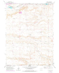
1963 Map of Altvan
USGS Topo · Published 1978About this map
The high plains of the Laramie Co Weld Co borderlands are defined by an intricate network of irrigation and livestock infrastructure in this 1963 survey. Situated near the settlement of Altvan, the landscape is etched with historical water management features like Stewart Ditch and Kingman Ditch, which redirect the flow of Crow Creek and Little Simpson Creek toward ranching operations. The topography is dotted with numerous named windmills, including Century Windmill, Heifer Pasture Windmill, and Bedortha Windmill, highlighting the critical importance of groundwater for this arid region.
Find a feature on this map
22 named features on this map. Tap any name to fly to it.
Don’t see what you’re looking for? This feature index may not catch every label — zoom into the map to look around manually.
Map Details
Editions of this 1963 Altvan Map
This is the sole edition of this map. No revisions or reprints were ever made.
Other maps of this area

1908 · Eaton
USGS Topo · 1:125,000

1910 · Eaton
USGS Topo · 1:125,000

1911 · Cheyenne
USGS Topo · 1:125,000

1914 · Cheyenne
USGS Topo · 1:125,000

1950 · Cheyenne
USGS Topo · 1:62,500

1954 · Cheyenne
USGS Topo · 1:250,000

1954 · Greeley
USGS Topo · 1:250,000

1957 · Greeley
USGS Topo · 1:250,000

1958 · Cheyenne
USGS Topo · 1:250,000

1958 · Greeley
USGS Topo · 1:250,000