
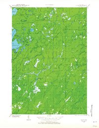
1938 Map of Alvin
USGS Topo · Published 1956About this map
The Nicolet National Forest dominates this landscape, showing a region defined by early 20th-century timber extraction and conservation infrastructure. The northern reaches of Forest County and Vilas County are captured here as they appeared in 1938, a period when the Lumber RR and numerous truck trails, such as Truck Trail No 406, supported the local logging industry. The settlement of Alvin serves as the primary hub, surrounded by a dense network of water bodies including Howell Lake and the Pine River.
Find a feature on this map
55 named features on this map. Tap any name to fly to it.
Don’t see what you’re looking for? This feature index may not catch every label — zoom into the map to look around manually.
Map Details
Editions of this 1938 Alvin Map
2 editions found
Other maps of this area

1898 · Iron River
USGS Topo · 1:62,500

1928 · Three Lakes
USGS Topo · 1:48,000

1938 · Phelps
USGS Topo · 1:48,000

1938 · Three Lakes
USGS Topo · 1:48,000

1939 · Crandon
USGS Topo · 1:48,000

1939 · Laona
USGS Topo · 1:48,000

1939 · Long Lake
USGS Topo · 1:48,000

1940 · Monico
USGS Topo · 1:48,000

1941 · Crandon
USGS Topo · 1:48,000

1944 · Iron River
USGS Topo · 1:24,000