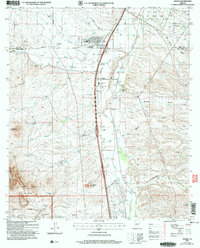
2004 Map of Amado
USGS Topo · Published 2006About this map
The Santa Cruz River valley near the Pima and Santa Cruz county line defines this landscape, where ranching heritage meets early 21st-century infrastructure. Small hubs like Arivaca Junction and Amado anchor the valley floor, alongside a mixture of residential developments such as Greyhound Park and the Mobile Home Park. The geography transitions from the flatlands of the San Ignacio De La Canoa Grant to the rising terrain of Diablito Mountain and the Coronado National Forest. This era shows a complex land-use pattern, including the US Military Use Area and numerous family-named landmarks like Rex Ranch, PM Ranch, and Sopori Ranch. Local education is centered at the Sopori Sch, while the arid landscape is navigated via named water sources like Agua Linda and Chivas Spring.
Find a feature on this map
38 named features on this map. Tap any name to fly to it.
Don’t see what you’re looking for? This feature index may not catch every label — zoom into the map to look around manually.
Map Details
Editions of this 2004 Amado Map
This is the sole edition of this map. No revisions or reprints were ever made.
Other maps of this area

1904 · Patagonia
USGS Topo · 1:125,000

1905 · Patagonia
USGS Topo · 1:125,000

1920 · Arivaca
USGS Topo · 1:125,000

1922 · Agus Caliente
USGS Topo · 1:62,500

1925 · Samaniego Peak
USGS Topo · 1:62,500

1926 · Helvetia
USGS Topo · 1:62,500

1939 · Twin Buttes
USGS Topo · 1:62,500

1939 · Tubac
USGS Topo · 1:62,500

1941 · Twin Buttes
USGS Topo · 1:62,500

1943 · Tubac
USGS Topo · 1:62,500