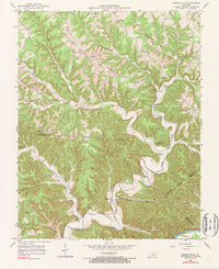
1953 Map of Amandaville
USGS Topo · Published 1990About this map
Crocus Creek meanders through a landscape of sharp ridges and deep hollows where Adair, Cumberland, and Russell counties meet. This mid-century topography reveals a rural society built on family-named landmarks and high-ground ridges, such as Pearl Ridge and Bard Ridge, which provided the only level ground for travel and settlement. The Cumberland River forms the southern boundary of this study, fed by numerous tributaries like Harrods Fork and Sand Lick Creek.
Find a feature on this map
46 named features on this map. Tap any name to fly to it.
Don’t see what you’re looking for? This feature index may not catch every label — zoom into the map to look around manually.
Map Details
Editions of this 1953 Amandaville Map
4 editions found
Other maps of this area

1953 · Gradyville
USGS Topo · 1:24,000

1953 · Breeding
USGS Topo · 1:24,000

1953 · Waterview
USGS Topo · 1:24,000

1953 · Amandaville
USGS Topo · 1:24,000

1953 · Montpelier
USGS Topo · 1:24,000

1953 · Burkesville
USGS Topo · 1:24,000

1953 · Wolf Creek Dam
USGS Topo · 1:24,000

1953 · Creelsboro
USGS Topo · 1:24,000

1954 · Columbia
USGS Topo · 1:24,000

1956 · Corbin
USGS Topo · 1:250,000