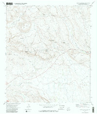
1971 Map of Amarilla Mountain
USGS Topo · Published 1987About this map
Mining operations and remote desert outposts characterize this portion of Brewster County as surveyed in the early 1970s. The landscape is marked by the presence of the Colquitt-Tigner Mine and several unnamed mines scattered near California Hill and Clay Mountain, reflecting the area's geological and industrial history. Travel through this arid terrain relied on a network of a Trail, Jeep Trail, and Pack Trail, connecting essential water sources like Comanche Spring, Lowes Tinaja, and Comanche Creek. Significant topographic landmarks including Amarilla Mountain, Tres Cuevas Mountain, and the Terlingua Sinkhole dominate the southern reach of the region. This survey also records Coltrin Camp and the eastern edge of Big Bend Nat Park, providing a record of the human presence and land use in this part of the Trans-Pecos before modern developments altered these remote routes.
Find a feature on this map
26 named features on this map. Tap any name to fly to it.
Don’t see what you’re looking for? This feature index may not catch every label — zoom into the map to look around manually.
Map Details
Editions of this 1971 Amarilla Mountain Map
2 editions found
Other maps of this area

1903 · Terlingua
USGS Topo · 1:125,000

1904 · Terlingua
USGS Topo · 1:125,000

1931 · Lajitas
USGS Topo · 1:62,500

1959 · Emory Peak
USGS Topo · 1:250,000

1965 · Emory Peak
USGS Topo · 1:250,000

1971 · Yellow Hill
USGS Topo · 1:24,000

1971 · Terlingua
USGS Topo · 1:24,000

1971 · Amarilla Mountain
USGS Topo · 1:24,000
1971 · The Solitario
USGS Topo · 1:24,000
1971 · Hen Egg Mountain
USGS Topo · 1:24,000