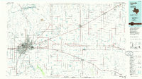
1986 Map of Amarillo
USGS Topo · Published 1986About this map
The Pantex Plant stands as a significant industrial presence northeast of Amarillo, marking the high plains with its expansive facility near the Texas Technological University Research Farm. This mid-1980s landscape is defined by the convergence of major rail lines, including the Atchison Topeka and Santa Fe and the Burlington Northern, which link grain-handling settlements like Panhandle, White Deer, and Groom.
Find a feature on this map
66 named features on this map. Tap any name to fly to it.
Don’t see what you’re looking for? This feature index may not catch every label — zoom into the map to look around manually.
Map Details
Editions of this 1986 Amarillo Map
2 editions found
Other maps of this area

1934 · Ady
USGS Topo · 1:62,500

1934 · Cliffside
USGS Topo · 1:62,500

1936 · Fourways
USGS Topo · 1:62,500

1936 · Cliffside
USGS Topo · 1:62,500

1936 · Ady
USGS Topo · 1:62,500

1939 · Sanford
USGS Topo · 1:62,500

1953 · Chunky
USGS Topo · 1:24,000

1953 · Marsh
USGS Topo · 1:24,000

1953 · Puente
USGS Topo · 1:24,000

1953 · Alibates Ranch
USGS Topo · 1:24,000