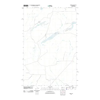
2011 Map of Amber
USGS Topo · Published 2011About this map
Amber sits at the northern edge of this landscape, positioned between the waters of Alkali Lake and Amber Lake. The terrain is defined by a series of elongated lakes and drainage systems, including Williams Lake and Badger Lake, which follow the northeast-to-southwest orientation characteristic of the Channeled Scablands. A network of rural roads such as W Pine Springs Rd and S Mullinix Rd connects these water bodies, reflecting a region where geography dictates movement and settlement patterns. To the south, Negro Creek meanders across the territory, eventually intersecting with roads like Rock Lake Rd and Belsby Rd. The map illustrates a contemporary rural environment where large water features and small springs like Cherry Springs serve as primary landmarks for local residents and genealogists tracing the development of Spokane County's outlying reaches.
Find a feature on this map
32 named features on this map. Tap any name to fly to it.
Don’t see what you’re looking for? This feature index may not catch every label — zoom into the map to look around manually.
Map Details
Editions of this 2011 Amber Map
This is the sole edition of this map. No revisions or reprints were ever made.
Other maps of this area

1954 · Cheney
USGS Topo · 1:62,500

1954 · Sprague
USGS Topo · 1:62,500

1955 · Spokane
USGS Topo · 1:250,000

1958 · Spokane
USGS Topo · 1:250,000

1964 · Lamont NE
USGS Topo · 1:24,000

1964 · Rock Lake
USGS Topo · 1:24,000

1964 · Pine City
USGS Topo · 1:24,000
1980 · Chapman Lake
USGS Topo · 1:24,000
1980 · Lance Hills
USGS Topo · 1:24,000
1980 · Cheney
USGS Topo · 1:24,000