
1964 Map of Lamont NE
USGS Topo · Published 1965About this map
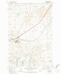
The Spokane Portland and Seattle railroad cuts through the northwestern corner of this landscape in Whitman County, following the natural contours near the northern boundary. The terrain is defined by an intricate network of coulees and drainage systems, where water bodies like Stoner Lake and Big Lake gather in the depressions of the upland plateau. In the eastern portion of the quadrangle, Imbler Creek and Packer Creek wind through the valleys, illustrating the hydraulic patterns of this agricultural region. Transportation in the mid-1960s relied on corridors such as Elliott Road, which connects the scattered farmsteads across the hills. This survey provides a clear look at the rural infrastructure of the Pacific Northwest before the expansion of modern highway systems, emphasizing the relationship between the rail lines and the undulating geography of eastern Washington.
Find a feature on this map
7 named features on this map. Tap any name to fly to it.
Don’t see what you’re looking for? This feature index may not catch every label — zoom into the map to look around manually.
Map Details
Editions of this 1964 Lamont NE Map
This is the sole edition of this map. No revisions or reprints were ever made.
Other maps of this area

1954 · Cheney
USGS Topo · 1:62,500

1954 · Sprague
USGS Topo · 1:62,500

1955 · Spokane
USGS Topo · 1:250,000

1958 · Spokane
USGS Topo · 1:250,000

1964 · Lamont NW
USGS Topo · 1:24,000

1964 · Rock Lake
USGS Topo · 1:24,000

1964 · Texas Lake
USGS Topo · 1:24,000

1964 · Revere
USGS Topo · 1:24,000

1964 · Ewan
USGS Topo · 1:24,000
1981 · Sprague
USGS Topo · 1:24,000