
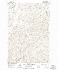
1964 Map of Ewan
USGS Topo · Published 1965About this map
Ewan sits at the northern edge of this Whitman County landscape, where the Chicago Milwaukee St Paul and Pacific railroad tracks follow the winding course of Cottonwood Creek. The map documents a rural transition point in the mid-1960s, noting the dual identity of Willada (Lancaster PO) further south along the Union Pacific line. This intersection of rail transport and small-town post offices reflects the agrarian commerce typical of the Palouse region. The terrain is defined by a dense network of coulees and drainages, including Downing Creek and Kamiache Creek, which eventually give way to the Palouse R at the southern boundary. Distinctive landmarks such as the Schierman summit and a remote Landing Strip appear alongside local water sources like Stevens Lake, providing a clear record of land use and water management in this eastern Washington wheat-growing territory.
Find a feature on this map
16 named features on this map. Tap any name to fly to it.
Don’t see what you’re looking for? This feature index may not catch every label — zoom into the map to look around manually.
Map Details
Editions of this 1964 Ewan Map
2 editions found
Other maps of this area

1950 · La Crosse
USGS Topo · 1:62,500

1950 · Endicott
USGS Topo · 1:62,500

1952 · La Crosse
USGS Topo · 1:62,500

1955 · Pullman
USGS Topo · 1:250,000

1955 · Spokane
USGS Topo · 1:250,000

1958 · Spokane
USGS Topo · 1:250,000

1958 · Pullman
USGS Topo · 1:250,000

1964 · Lamont NE
USGS Topo · 1:24,000

1964 · St. John
USGS Topo · 1:24,000

1964 · Rock Lake
USGS Topo · 1:24,000