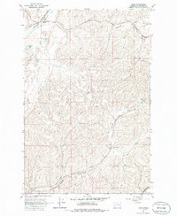
1964 Map of Ewan
USGS Topo · Published 1986About this map
Ewan sits at the northern edge of this mid-1960s landscape, serving as a hub where the Chicago Milwaukee St Paul and Pacific railroad follows the winding path of Cottonwood Creek. The terrain is defined by the deep incisions of the Palouse region, where Kamiache Creek and Downing Creek have carved distinct drainage patterns into the plateau. To the south, the Union Pacific line tracks alongside East Fork Downing Creek, illustrating the heavy reliance on these natural corridors for transcontinental rail transport. Small-scale human activity is visible through scattered landmarks such as the Schierman farmstead, a solitary Landing Strip, and a Gravel Pit. The map captures a moment in the mid-century agricultural economy before the modernization of the Palouse R basin, showing the distribution of water resources like Stevens Lake and the Pleasant Valley Creek drainage within Pleasant Valley.
Find a feature on this map
16 named features on this map. Tap any name to fly to it.
Don’t see what you’re looking for? This feature index may not catch every label — zoom into the map to look around manually.
Map Details
Editions of this 1964 Ewan Map
2 editions found

Other maps of this area

1950 · La Crosse
USGS Topo · 1:62,500

1950 · Endicott
USGS Topo · 1:62,500

1952 · La Crosse
USGS Topo · 1:62,500

1955 · Pullman
USGS Topo · 1:250,000

1955 · Spokane
USGS Topo · 1:250,000

1958 · Spokane
USGS Topo · 1:250,000

1958 · Pullman
USGS Topo · 1:250,000

1964 · Lamont NE
USGS Topo · 1:24,000

1964 · St. John
USGS Topo · 1:24,000

1964 · Rock Lake
USGS Topo · 1:24,000