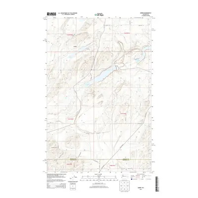
2014 Map of Amber
USGS Topo · Published 2014About this map
The small community of Amber serves as the focal point for this landscape in the eastern Washington scablands, situated at the boundary of Spokane and Whitman counties. The terrain is defined by a series of elongated glacial lakes and coulees, including Amber Lake, Williams Lake, and Badger Lake, which trace a southwest-to-northeast orientation through the basalt-carved topography. These water bodies are connected by drainage systems like Negro Cr and Imbler Cr, creating a distinct pattern of wetlands and seasonal water sources such as Cherry Springs.
Find a feature on this map
35 named features on this map. Tap any name to fly to it.
Don’t see what you’re looking for? This feature index may not catch every label — zoom into the map to look around manually.
Map Details
Editions of this 2014 Amber Map
This is the sole edition of this map. No revisions or reprints were ever made.
Other maps of this area

1954 · Cheney
USGS Topo · 1:62,500

1954 · Sprague
USGS Topo · 1:62,500

1955 · Spokane
USGS Topo · 1:250,000

1958 · Spokane
USGS Topo · 1:250,000

1964 · Lamont NE
USGS Topo · 1:24,000

1964 · Rock Lake
USGS Topo · 1:24,000

1964 · Pine City
USGS Topo · 1:24,000
1980 · Chapman Lake
USGS Topo · 1:24,000
1980 · Lance Hills
USGS Topo · 1:24,000
1980 · Cheney
USGS Topo · 1:24,000