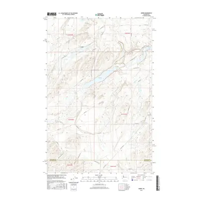
2017 Map of Amber
USGS Topo · Published 2017About this map
Amber sits at the heart of this landscape, a settlement defined by its proximity to a chain of distinct glacial lakes. The area is characterized by the irregular topography of the Channeled Scablands, where Amber Lake, Williams Lake, and Badger Lake fill depressions between rocky outcrops. These water bodies, along with the smaller Alkali Lake to the north, dominate the local geography and have historically dictated the placement of roads and homesteads.
Find a feature on this map
37 named features on this map. Tap any name to fly to it.
Don’t see what you’re looking for? This feature index may not catch every label — zoom into the map to look around manually.
Map Details
Editions of this 2017 Amber Map
This is the sole edition of this map. No revisions or reprints were ever made.
Other maps of this area

1954 · Cheney
USGS Topo · 1:62,500

1954 · Sprague
USGS Topo · 1:62,500

1955 · Spokane
USGS Topo · 1:250,000

1958 · Spokane
USGS Topo · 1:250,000

1964 · Lamont NE
USGS Topo · 1:24,000

1964 · Rock Lake
USGS Topo · 1:24,000

1964 · Pine City
USGS Topo · 1:24,000
1980 · Chapman Lake
USGS Topo · 1:24,000
1980 · Lance Hills
USGS Topo · 1:24,000
1980 · Cheney
USGS Topo · 1:24,000