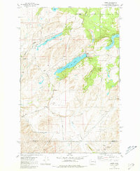
1981 Map of Amber
USGS Topo · Published 1981About this map
Amber sits at the heart of this landscape, positioned along the Burlington Northern railroad corridor. The area is defined by a series of elongated water bodies, including Amber Lake, Williams Lake, and Badger Lake, which follow the natural northeast-southwest orientation of the Lance Hills. The presence of several Gravel Pits and a Borrow Pit suggests a history of local resource extraction, while a Historical Monument located near Martin Road provides a specific point of interest for local researchers. The southern portion of the sheet reveals the border between Spokane Co and Whitman Co, where the terrain transitions toward Imbler Creek. A network of rural routes such as Mullinix Road and Gossalman Road connects isolated farmsteads and agricultural storage facilities like the Storage Bins found throughout the county line area.
Find a feature on this map
29 named features on this map. Tap any name to fly to it.
Don’t see what you’re looking for? This feature index may not catch every label — zoom into the map to look around manually.
Map Details
Editions of this 1981 Amber Map
This is the sole edition of this map. No revisions or reprints were ever made.
Other maps of this area

1954 · Cheney
USGS Topo · 1:62,500

1954 · Sprague
USGS Topo · 1:62,500

1955 · Spokane
USGS Topo · 1:250,000

1958 · Spokane
USGS Topo · 1:250,000

1964 · Lamont NE
USGS Topo · 1:24,000

1964 · Rock Lake
USGS Topo · 1:24,000

1964 · Pine City
USGS Topo · 1:24,000
1980 · Chapman Lake
USGS Topo · 1:24,000
1980 · Lance Hills
USGS Topo · 1:24,000
1980 · Cheney
USGS Topo · 1:24,000