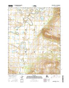
2016 Map of Ambler River A-1 SW
USGS Topo · Published 2016About this map
Kogoluktuk River meanders across the northwestern portion of this Arctic quadrangle, defining a landscape shaped by glacial and alluvial processes in the Ambler Lowland. This 2016 survey illustrates a remote expanse of the Alaska-Northwest Arctic Borough, where the terrain transitions from the low-lying river plains in the west toward the increasing elevations of the eastern hills. The lack of man-made structures, roads, or permanent settlements underscores the wilderness character of the region, emphasizing the natural topography and the intricate drainage patterns of the Kogoluktuk River system. The map serves as a contemporary record of this sub-Arctic environment, focusing on the hydrological and geomorphic features of the Ambler basin before any modern development or infrastructure has reached this specific sector.
Find a feature on this map
6 named features on this map. Tap any name to fly to it.
Don’t see what you’re looking for? This feature index may not catch every label — zoom into the map to look around manually.
Map Details
Editions of this 2016 Ambler River A-1 SW Map
This is the sole edition of this map. No revisions or reprints were ever made.
Other maps of this area

1951 · Shungnak
USGS Topo · 1:250,000

1951 · Ambler River
USGS Topo · 1:250,000

1955 · Shungnak
USGS Topo · 1:250,000

1955 · Shungnak D-2
USGS Topo · 1:63,360

1956 · Ambler River
USGS Topo · 1:250,000

1964 · Shungnak
USGS Topo · 1:250,000

1964 · Ambler River
USGS Topo · 1:250,000
1985 · Ambler River A-2
USGS Topo · 1:63,360
1985 · Shungnak D-1
USGS Topo · 1:63,360
1985 · Ambler River A-1
USGS Topo · 1:63,360