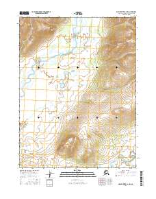
2016 Map of Ambler River A-2 NW
USGS Topo · Published 2016About this map
The Ambler River winds through this northern Alaskan landscape, creating a complex network of braided channels and seasonal wetlands. In this corner of the Northwest Arctic Borough, the water dictates the character of the land, as the river shifts through its floodplain against the backdrop of rising terrain. The drainage patterns of the Shungnak River in the southeastern corner provide a distinct contrast to the broader glacial valley of the Ambler, illustrating the diverse hydrological systems that define this part of the Arctic. Without permanent settlements or roads, the map captures a wilderness in its natural state during the early twenty-first century, serving as a baseline for understanding the region's environmental evolution and the traditional lands within t21n r8e and t20n r9e.
Find a feature on this map
6 named features on this map. Tap any name to fly to it.
Don’t see what you’re looking for? This feature index may not catch every label — zoom into the map to look around manually.
Map Details
Editions of this 2016 Ambler River A-2 NW Map
This is the sole edition of this map. No revisions or reprints were ever made.
Other maps of this area

1951 · Ambler River
USGS Topo · 1:250,000

1956 · Ambler River
USGS Topo · 1:250,000

1964 · Ambler River
USGS Topo · 1:250,000
1985 · Ambler River A-3
USGS Topo · 1:63,360
1985 · Ambler River A-2
USGS Topo · 1:63,360
1990 · Ambler River B-3
USGS Topo · 1:63,360
1990 · Ambler River B-2
USGS Topo · 1:63,360
2016 · Ambler River A-2 NE
USGS Topo · 1:25,000
2016 · Ambler River A-3 NE
USGS Topo · 1:25,000
2016 · Ambler River B-2 SW
USGS Topo · 1:25,000