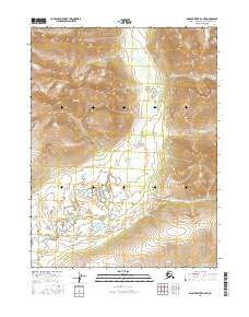
2016 Map of Ambler River A-2 NE
USGS Topo · Published 2016About this map
The Schwatka Mountains dominate the northern landscape of this interior Alaskan region, their steep elevation contours indicating the dramatic transition from rugged heights to the river valley below. Carving a complex path through the southern half of the sheet, the Shungnak River exhibits a meandering pattern with numerous oxbows and marshy lowlands typical of the Arctic's high-latitude hydrology. This 2016 survey by the U.S. Geological Survey documents a nearly pristine wilderness within the Northwest Arctic borough, where the land remains defined by its natural watercourses and relief rather than human infrastructure. The mapping reveals a topographical divide between the high peaks and the braided river systems that shape the local ecosystem.
Find a feature on this map
6 named features on this map. Tap any name to fly to it.
Don’t see what you’re looking for? This feature index may not catch every label — zoom into the map to look around manually.
Map Details
Editions of this 2016 Ambler River A-2 NE Map
This is the sole edition of this map. No revisions or reprints were ever made.
Other maps of this area

1951 · Ambler River
USGS Topo · 1:250,000

1956 · Ambler River
USGS Topo · 1:250,000

1964 · Ambler River
USGS Topo · 1:250,000
1985 · Ambler River A-2
USGS Topo · 1:63,360
1985 · Ambler River A-1
USGS Topo · 1:63,360
1990 · Ambler River B-1
USGS Topo · 1:63,360
1990 · Ambler River B-2
USGS Topo · 1:63,360
2016 · Ambler River B-2 SW
USGS Topo · 1:25,000
2016 · Ambler River A-1 SW
USGS Topo · 1:25,000
2016 · Ambler River A-2 NW
USGS Topo · 1:25,000