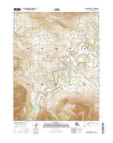
2016 Map of Ambler River A-2 SE
USGS Topo · Published 2016About this map
Ambler Lowland dominates the northern reaches of this Alaskan interior landscape, where complex wetland systems and small ponds define the terrain north of the Arctic Circle. The Kogoluktuk River meanders sharply through the southern half of the quadrangle, exhibiting the dramatic oxbows and sediment patterns typical of a high-latitude river system. Along its path, it is joined by smaller tributaries including Riley Cr and Canyon Cr, which drain the surrounding foothills. This 2016 survey, produced with data from the Alaska Dept. of Transportation and the BLM, reflects the remote and largely uninhabited nature of the Northwest Arctic Borough. The map provides a precise look at the hydrology and land partitions within the Public Land Survey System, including sections of t19n r10e and t20n r10e.
Find a feature on this map
8 named features on this map. Tap any name to fly to it.
Don’t see what you’re looking for? This feature index may not catch every label — zoom into the map to look around manually.
Map Details
Editions of this 2016 Ambler River A-2 SE Map
This is the sole edition of this map. No revisions or reprints were ever made.
Other maps of this area

1951 · Shungnak
USGS Topo · 1:250,000

1951 · Ambler River
USGS Topo · 1:250,000

1955 · Shungnak
USGS Topo · 1:250,000

1955 · Shungnak D-2
USGS Topo · 1:63,360

1956 · Ambler River
USGS Topo · 1:250,000

1964 · Shungnak
USGS Topo · 1:250,000

1964 · Ambler River
USGS Topo · 1:250,000
1985 · Ambler River A-2
USGS Topo · 1:63,360
1985 · Shungnak D-1
USGS Topo · 1:63,360
1985 · Ambler River A-1
USGS Topo · 1:63,360