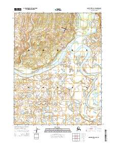
2015 Map of Ambler River A-4 SW
USGS Topo · Published 2015About this map
The settlement of Ambler serves as the focal point of this Northwest Arctic survey, situated at the confluence of the Kobuk River and the south-flowing Ambler River. The community's infrastructure is clearly defined, featuring local routes like Ambler Avenue, Waring Street, and Brooks Street, which connect the residential area to the vital Ambler Airport. The surrounding geography is defined by a complex network of arctic waterways, including the winding Kopshesut Cr and Mishuk Cr, which weave through the lowlands west of the main river systems. This 2015 study illustrates the intersection of a modern remote hub with its traditional riverine environment, showing the local Landfill Access Road extending into the brush, while the broader landscape remains dominated by the broad, braided channels of the Kobuk.
Find a feature on this map
15 named features on this map. Tap any name to fly to it.
Don’t see what you’re looking for? This feature index may not catch every label — zoom into the map to look around manually.
Map Details
Editions of this 2015 Ambler River A-4 SW Map
This is the sole edition of this map. No revisions or reprints were ever made.
Other maps of this area

1951 · Shungnak
USGS Topo · 1:250,000

1951 · Ambler River
USGS Topo · 1:250,000

1955 · Shungnak
USGS Topo · 1:250,000

1955 · Ambler River A-4
USGS Topo · 1:63,360

1955 · Shungnak D-4
USGS Topo · 1:63,360

1955 · Shungnak D-5
USGS Topo · 1:63,360

1955 · Ambler River A-5
USGS Topo · 1:63,360

1956 · Ambler River
USGS Topo · 1:250,000

1964 · Shungnak
USGS Topo · 1:250,000

1964 · Ambler River
USGS Topo · 1:250,000