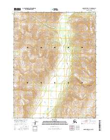
2016 Map of Ambler River B-3 SE
USGS Topo · Published 2016About this map
Kalurivik Cr defines the central drainage of this Northwest Arctic landscape, carving a serpentine path through the interior of the Ambler River region. This 2016 survey, produced in collaboration with the Alaska Dept. of Transportation and the BLM, documents the complex hydrology and high-elevation relief of the Brooks Range foothills. The map focuses on the high terrain spanning townships T22N R8E and T23N R7E, where the steep contour intervals reveal a landscape shaped by glacial activity and permafrost. On the southeastern edge, the headwaters of Nanirakkohort Cr begin their descent, providing a detailed record of the remote watershed before it joins larger river systems. This is a purely wilderness-focused sheet, devoid of permanent settlements or structures, serving as a baseline for environmental study and modern backcountry navigation.
Find a feature on this map
8 named features on this map. Tap any name to fly to it.
Don’t see what you’re looking for? This feature index may not catch every label — zoom into the map to look around manually.
Map Details
Editions of this 2016 Ambler River B-3 SE Map
This is the sole edition of this map. No revisions or reprints were ever made.
Other maps of this area

1951 · Ambler River
USGS Topo · 1:250,000

1956 · Ambler River
USGS Topo · 1:250,000

1964 · Ambler River
USGS Topo · 1:250,000
1985 · Ambler River A-3
USGS Topo · 1:63,360
1985 · Ambler River A-2
USGS Topo · 1:63,360
1990 · Ambler River B-3
USGS Topo · 1:63,360
1990 · Ambler River B-2
USGS Topo · 1:63,360
2015 · Ambler River B-3 SW
USGS Topo · 1:25,000
2015 · Ambler River A-3 NW
USGS Topo · 1:25,000
2016 · Ambler River A-3 NE
USGS Topo · 1:25,000