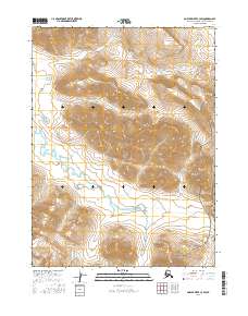
2016 Map of Ambler River C-3 SW
USGS Topo · Published 2016About this map
Noatak National Preserve protects a vast stretch of the Arctic wilderness within this 2016 survey, where the landscape is defined by the drainages of the Brooks Range. The topographical data reveals a terrain of high ridges and narrow valleys, carved by the winding course of Amakomanak Creek. This waterway meanders across the southern half of the quadrangle, creating a complex system of seasonal wetlands and small ponds in the low-lying areas. The survey highlights the intersection of several townships, including t25n r7e and t25n r6e, illustrating the formal administrative grid imposed on this remote subarctic environment. The lack of roads or established settlements emphasizes the undisturbed character of the preserve during this period.
Find a feature on this map
9 named features on this map. Tap any name to fly to it.
Don’t see what you’re looking for? This feature index may not catch every label — zoom into the map to look around manually.
Map Details
Editions of this 2016 Ambler River C-3 SW Map
This is the sole edition of this map. No revisions or reprints were ever made.
Other maps of this area

1951 · Ambler River
USGS Topo · 1:250,000

1956 · Ambler River
USGS Topo · 1:250,000

1964 · Ambler River
USGS Topo · 1:250,000
1990 · Ambler River B-3
USGS Topo · 1:63,360
1990 · Ambler River B-4
USGS Topo · 1:63,360
1990 · Ambler River C-4
USGS Topo · 1:63,360
1990 · Ambler River C-3
USGS Topo · 1:63,360
2015 · Ambler River B-4 NE
USGS Topo · 1:25,000
2016 · Ambler River C-3 NW
USGS Topo · 1:25,000
2016 · Ambler River C-3 NE
USGS Topo · 1:25,000