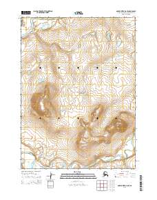
2015 Map of Ambler River D-5 SE
USGS Topo · Published 2015About this map
Noatak National Preserve occupies the central portion of this wilderness landscape, where the confluence of major Arctic waterways defines the local geography. The Noatak River enters from the northwest, while the Cutler River and Imelyak River course through the southern sections. This 2015 survey illustrates a terrain of extreme isolation, devoid of roads or permanent settlements, where the drainage patterns of these rivers are the primary landmarks. The map details the complex topography surrounding the river valleys within several townships, including t29n r3e and t28n r4e, providing an exact view of the hydrological network before these waters exit the preserve. This survey by the U.S. Geological Survey is an essential record of the undisturbed Arctic interior, highlighting the relationship between these significant water bodies and the protected land they carve.
Find a feature on this map
10 named features on this map. Tap any name to fly to it.
Don’t see what you’re looking for? This feature index may not catch every label — zoom into the map to look around manually.
Map Details
Editions of this 2015 Ambler River D-5 SE Map
This is the sole edition of this map. No revisions or reprints were ever made.
Other maps of this area

1951 · Ambler River
USGS Topo · 1:250,000

1956 · Ambler River
USGS Topo · 1:250,000

1964 · Ambler River
USGS Topo · 1:250,000
1990 · Ambler River D-4
USGS Topo · 1:63,360
1990 · Ambler River C-5
USGS Topo · 1:63,360
1990 · Ambler River D-5
USGS Topo · 1:63,360
1990 · Ambler River C-4
USGS Topo · 1:63,360
2015 · Ambler River D-5 NE
USGS Topo · 1:25,000
2015 · Ambler River C-5 NW
USGS Topo · 1:25,000
2015 · Ambler River C-5 NE
USGS Topo · 1:25,000