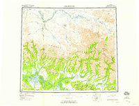
1956 Map of Ambler River
USGS Topo · Published 1959About this map
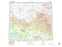
The Brooks Range dominates this mid-century survey of Alaska's northern interior, where the Baird Mountains and Schwatka Mountains meet. In the southwest, the remarkable Great Kobuk Sand Dunes and Little Kobuk Sand Dunes sit north of the Waring Mountains, creating a distinct desert-like landscape amidst the subarctic terrain. The river systems of the Kobuk River and Noatak River serve as the primary corridors through the wilderness, with the Ambler Lowland providing a broad valley for the Ambler River. Potential mineral wealth is indicated by labels for Mines and Mine near Asbestos Mountain, Iron Mtn, and the Jade Mountains. Human presence is sparse, marked primarily by scattered Cabins and a designated Landing Area along the riverbanks, reflecting the region's character before modern infrastructure development.
Find a feature on this map
63 named features on this map. Tap any name to fly to it.
Don’t see what you’re looking for? This feature index may not catch every label — zoom into the map to look around manually.
Map Details
Editions of this 1956 Ambler River Map
6 editions found

Other maps of this area

1951 · Baird Mountains
USGS Topo · 1:250,000

1951 · Selawik
USGS Topo · 1:250,000

1951 · Shungnak
USGS Topo · 1:250,000

1951 · Hughes
USGS Topo · 1:250,000

1951 · Survey Pass
USGS Topo · 1:250,000

1951 · Howard Pass
USGS Topo · 1:250,000

1951 · Ambler River
USGS Topo · 1:250,000

1951 · Misheguk Mountain
USGS Topo · 1:250,000

1951 · Killik River
USGS Topo · 1:250,000

1955 · Shungnak
USGS Topo · 1:250,000