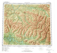
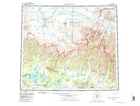
1956 Map of Ambler River
USGS Topo · Published 1977About this map
The Brooks Range dominates this mid-century survey, where the rugged peaks of the Baird Mountains and Schwatka Mountains define the northern Arctic landscape. In the southern portion of the map, the Ambler River and Kogoluktuk River flow toward the Ambler Lowland, a region marked by significant mineral exploration at Bornite and the Partner Mine. This period of mapping captures the wilderness before extensive modern development, highlighting traditional transit points like Onion Portage on the Kobuk River and specialized terrain such as the Great Kobuk Sand Dunes. Remote outposts are noted by scattered cabins and the Ambler Landing Area, while the North Slope Borough Boundary marks the political division across the high alpine passes of Ivishak Pass and Nakmaktuak Pass.
Find a feature on this map
84 named features on this map. Tap any name to fly to it.
Don’t see what you’re looking for? This feature index may not catch every label — zoom into the map to look around manually.
Map Details
Editions of this 1956 Ambler River Map
6 editions found

Other maps of this area

1951 · Baird Mountains
USGS Topo · 1:250,000

1951 · Selawik
USGS Topo · 1:250,000

1951 · Shungnak
USGS Topo · 1:250,000

1951 · Hughes
USGS Topo · 1:250,000

1951 · Survey Pass
USGS Topo · 1:250,000

1951 · Howard Pass
USGS Topo · 1:250,000

1951 · Ambler River
USGS Topo · 1:250,000

1951 · Misheguk Mountain
USGS Topo · 1:250,000

1951 · Killik River
USGS Topo · 1:250,000

1955 · Shungnak
USGS Topo · 1:250,000