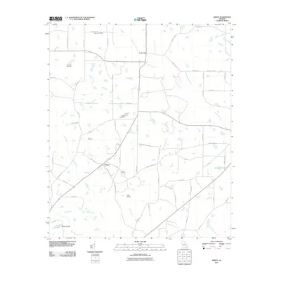
2011 Map of Amboy
USGS Topo · Published 2011About this map
The rural agricultural landscape of Turner County centers on Amboy and Double Run during the early 21st century. This region is characterized by an extensive network of named local roads and a sophisticated system of water management, evidenced by several recorded dams such as Whelchel Lake Dam, Gibbs Lake Dam, and Date Lake Dam. These structures manage the flow of various tributaries, including Double Run Creek, Deep Creek, and Wolf Creek, which drain the surrounding farmland. Genealogists will find significant value in the documentation of local family and community burial grounds, specifically Oklahoma Cemetery, Pate Cemetery, and Rainey Cemetery. The presence of numerous small bodies of water, including Gibbs Lake, Hobby Lake, and Tom Halls Pond, suggests a terrain shaped by both natural hydrology and intentional irrigation or recreational development within this Georgia community.
Find a feature on this map
67 named features on this map. Tap any name to fly to it.
Don’t see what you’re looking for? This feature index may not catch every label — zoom into the map to look around manually.
Map Details
Editions of this 2011 Amboy Map
This is the sole edition of this map. No revisions or reprints were ever made.
Other maps of this area

1953 · Waycross
USGS Topo · 1:250,000

1958 · Waycross
USGS Topo · 1:250,000

1973 · Irwinville
USGS Topo · 1:24,000

1973 · Ashburn
USGS Topo · 1:24,000

1973 · Bethel
USGS Topo · 1:24,000

1974 · Rebecca
USGS Topo · 1:24,000
1974 · Pitts
USGS Topo · 1:24,000

1974 · Amboy
USGS Topo · 1:24,000
1977 · Arabi
USGS Topo · 1:24,000
1977 · Rochelle
USGS Topo · 1:24,000