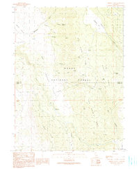
1990 Map of Ambrose Valley
USGS Topo · Published 1990About this map
Modoc National Forest encompasses the rugged landscape of this northern California terrain, where high-elevation drainage systems and prominent ridges define the local geography. The map captures a complex network of springs, including Pothole Spring, Stump Spring, and Yellow Jacket Spring, which provided essential water sources in this dry mountain environment. The intersection of the Modoc Co Lassen Co boundary splits the territory, while the Ash Creek Trail and Ash Creek Campground indicate the recreational and utility corridors established by the late 1980s. Natural features like Round Valley and Ambrose Valley are framed by substantial uplands such as Deer Spring Ridge and Slate Spring Ridge, illustrating the varied topography of the region. Local nomenclature is preserved through labels like Hunsinger Draw, Messenger Gulch, and Sweagert Flat, offering specific locations for family-named landmarks and historical land use.
Find a feature on this map
33 named features on this map. Tap any name to fly to it.
Don’t see what you’re looking for? This feature index may not catch every label — zoom into the map to look around manually.
Map Details
Editions of this 1990 Ambrose Valley Map
This is the sole edition of this map. No revisions or reprints were ever made.
Other maps of this area

1886 · Alturas
USGS Topo · 1:250,000

1892 · Alturas
USGS Topo · 1:250,000

1954 · Alturas
USGS Topo · 1:250,000

1958 · Alturas
USGS Topo · 1:250,000

1961 · Canby
USGS Topo · 1:62,500

1961 · Alturas
USGS Topo · 1:62,500

1962 · Alturas
USGS Topo · 1:250,000
1962 · Adin
USGS Topo · 1:62,500

1962 · Likely
USGS Topo · 1:62,500

1965 · Alturas
USGS Topo · 1:250,000