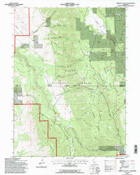
1993 Map of Ambrose Valley
USGS Topo · Published 1996About this map
Modoc National Forest land dominates this high-altitude landscape along the border of Modoc and Lassen counties. The map captures a rugged transition where the wide meadows of Ambrose Valley and Ash Valley meet the rising shoulders of Deer Spring Ridge and Slate Spring Ridge. This area is defined by its complex hydrology, featuring numerous named water sources such as Clark Springs, Shell Spring, and Sunflower Spring, which were vital for livestock and local homesteads in this arid terrain.
Find a feature on this map
45 named features on this map. Tap any name to fly to it.
Don’t see what you’re looking for? This feature index may not catch every label — zoom into the map to look around manually.
Map Details
Editions of this 1993 Ambrose Valley Map
This is the sole edition of this map. No revisions or reprints were ever made.
Other maps of this area

1886 · Alturas
USGS Topo · 1:250,000

1892 · Alturas
USGS Topo · 1:250,000

1954 · Alturas
USGS Topo · 1:250,000

1958 · Alturas
USGS Topo · 1:250,000

1961 · Canby
USGS Topo · 1:62,500

1961 · Alturas
USGS Topo · 1:62,500

1962 · Alturas
USGS Topo · 1:250,000
1962 · Adin
USGS Topo · 1:62,500

1962 · Likely
USGS Topo · 1:62,500

1965 · Alturas
USGS Topo · 1:250,000