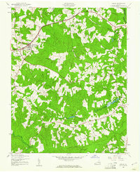
1943 Map of Amelia
USGS Topo · Published 1961About this map
Amelia serves as the central hub of this mid-century Virginia landscape, where the Southern railroad line dictates the local geography as it passes through Winterham and Otterburn. The mapping reveals a community deeply rooted in its local institutions, evidenced by a high density of rural gathering places such as Tabernacle Ch, Rennie Ch, and the Russell Grove High Sch. This era predates significant modernization, showing a patchwork of wooded terrain and small clearings defined by the branching waters of Smacks Creek and Beaverpond Creek. These waterways, along with landmarks like Davenport Pond, illustrate the drainage patterns that shaped early road placements and settlement clusters like Scotts Fork and Wilsons Corner.
Find a feature on this map
32 named features on this map. Tap any name to fly to it.
Don’t see what you’re looking for? This feature index may not catch every label — zoom into the map to look around manually.
Map Details
Editions of this 1943 Amelia Map
2 editions found
Other maps of this area

1891 · Farmville
USGS Topo · 1:125,000

1893 · Farmville
USGS Topo · 1:125,000

1897 · Amelia
USGS Topo · 1:125,000

1943 · Amelia
USGS Topo · 1:31,680

1943 · Goodes Bridge
USGS Topo · 1:31,680

1943 · Clayville
USGS Topo · 1:24,000
1943 · Chula
USGS Topo · 1:24,000

1943 · Richmond
USGS Topo · 1:250,000

1944 · Chula
USGS Topo · 1:31,680
1944 · Clayville
USGS Topo · 1:31,680