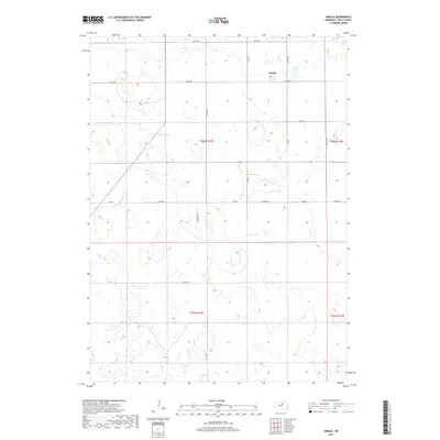
2017 Map of Amelia
USGS Topo · Published 2017About this map
The small unincorporated community of Amelia serves as the focal point of this Holt County landscape, situated at the intersection of several section-line roads in the northern portion of the quadrangle. The terrain is defined by the gentle drainage patterns of the S Fork Elkhorn River, which meanders through the central and western sections, and Dry Cr in the north. This 2017 survey reflects the enduring grid-based agricultural organization of the Nebraska Sandhills, where movement is dictated by a network of rural routes such as Hickory RD and 851st Rd. The map illustrates a sparse, ranch-oriented settlement pattern, with most development clustered near the established road intersections and along the river's path, providing a modern view of this rural interior.
Find a feature on this map
21 named features on this map. Tap any name to fly to it.
Don’t see what you’re looking for? This feature index may not catch every label — zoom into the map to look around manually.
Map Details
Editions of this 2017 Amelia Map
This is the sole edition of this map. No revisions or reprints were ever made.
Other maps of this area

1955 · O'Neill
USGS Topo · 1:250,000

1959 · O'Neill
USGS Topo · 1:250,000

1964 · Emmet SE
USGS Topo · 1:24,000

1964 · Emmet SW
USGS Topo · 1:24,000

1969 · O'Neill
USGS Topo · 1:250,000
1981 · Abbott Ranch
USGS Topo · 1:24,000

1981 · Swan Lake
USGS Topo · 1:24,000

1981 · Amelia
USGS Topo · 1:24,000
1981 · Miles Ranch
USGS Topo · 1:24,000
1981 · Chain Lake
USGS Topo · 1:24,000