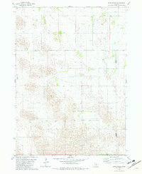
1981 Map of Miles Ranch
USGS Topo · Published 1982About this map
Miles Ranch sits at the heart of this 1981 topographic survey, illustrating the characteristic large-acreage landholding patterns of the Nebraska Sandhills. The landscape is defined by its subtle undulating contours and the intersection of three counties, where Holt, Wheeler, and Garfield counties meet. This period of mapping emphasizes the remote pastoral nature of the region, featuring only scattered outposts like Hanna Ranch and Schmidt Ranch. The presence of the Rush Lakebed and a solitary Grave suggest a landscape shaped by environmental change and isolated family histories. This survey provides an essential view for those researching the rural development of north-central Nebraska, where the tiny community of Dumas serves as one of the few named settlements among the vast ranchlands.
Find a feature on this map
10 named features on this map. Tap any name to fly to it.
Don’t see what you’re looking for? This feature index may not catch every label — zoom into the map to look around manually.
Map Details
Editions of this 1981 Miles Ranch Map
2 editions found
Other maps of this area

1954 · Gables NW
USGS Topo · 1:24,000

1954 · Bartlett NW
USGS Topo · 1:24,000

1954 · Gables
USGS Topo · 1:24,000

1955 · Broken Bow
USGS Topo · 1:250,000

1955 · O'Neill
USGS Topo · 1:250,000

1956 · Broken Bow
USGS Topo · 1:250,000

1959 · O'Neill
USGS Topo · 1:250,000

1969 · O'Neill
USGS Topo · 1:250,000

1981 · Amelia
USGS Topo · 1:24,000

1981 · Goose Lake SW
USGS Topo · 1:24,000