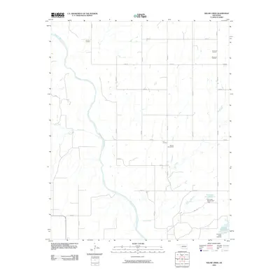
2009 Map of American Horse Lake
USGS Topo · Published 2009About this map
The Canadian River cuts diagonally across this portion of Blaine County, defining a landscape shaped by water and rural settlement. In the early 21st century, the area is characterized by scattered family and community sites, most notably the numerous burial grounds that speak to the local history of the region. Localities such as Whirlwind Cemetery, Emmanuel Cemetery, and Macedonia Cemetery are positioned among a grid of section roads like N2470 Rd and E0880 Rd.
Find a feature on this map
28 named features on this map. Tap any name to fly to it.
Don’t see what you’re looking for? This feature index may not catch every label — zoom into the map to look around manually.
Map Details
Editions of this 2009 American Horse Lake Map
This is the sole edition of this map. No revisions or reprints were ever made.
Other maps of this area

1942 · Geary
USGS Topo · 1:62,500

1955 · Clinton
USGS Topo · 1:250,000

1957 · Clinton
USGS Topo · 1:250,000

1964 · Oakwood
USGS Topo · 1:62,500

1964 · Weatherford
USGS Topo · 1:62,500

1972 · Watonga
USGS Topo · 1:24,000

1979 · Greenfield
USGS Topo · 1:24,000
1979 · Bridgeport
USGS Topo · 1:24,000
1985 · Weatherford
USGS Topo · 1:24,000
1985 · Hydro
USGS Topo · 1:24,000