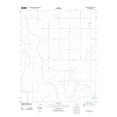
2012 Map of American Horse Lake
USGS Topo · Published 2012About this map
The Canadian River cuts a wide, meandering path through this western Oklahoma landscape, defining the local geography alongside several tributary streams. In the southeast corner, American Horse Lake and the managed waters of Groendyke Pond Number 1 provide significant landmarks within the undulating terrain. This 2012 survey illustrates a sparse settlement pattern dominated by a grid of rural roads, such as n2490 RD and e0880 RD, which connect isolated homesteads and burial sites. Genealogists will find interest in the scattered rural cemeteries that anchor the local history of the region, including Whirlwind Cem in the northwest and the grouped Emmanuel Cem and Macedonia Cem to the northeast. These small plots, along with Etna Cem further south, serve as the primary named historical markers in a territory largely defined by its drainage basins like Squaw Cr and Bear Cr.
Find a feature on this map
26 named features on this map. Tap any name to fly to it.
Don’t see what you’re looking for? This feature index may not catch every label — zoom into the map to look around manually.
Map Details
Editions of this 2012 American Horse Lake Map
This is the sole edition of this map. No revisions or reprints were ever made.
Other maps of this area

1942 · Geary
USGS Topo · 1:62,500

1955 · Clinton
USGS Topo · 1:250,000

1957 · Clinton
USGS Topo · 1:250,000

1964 · Oakwood
USGS Topo · 1:62,500

1964 · Weatherford
USGS Topo · 1:62,500

1972 · Watonga
USGS Topo · 1:24,000

1979 · Greenfield
USGS Topo · 1:24,000
1979 · Bridgeport
USGS Topo · 1:24,000
1985 · Weatherford
USGS Topo · 1:24,000
1985 · Hydro
USGS Topo · 1:24,000