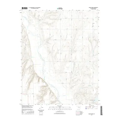
2016 Map of American Horse Lake
USGS Topo · Published 2016About this map
The Canadian River cuts a wide, braided path through this section of Blaine County, Oklahoma, defining a landscape where prairie plateaus meet deeply carved drainages. Family and community heritage is anchored by several burial sites, including Whirlwind Cem in the northwest and the cluster of Emmanuel Cem and Macedonia Cem near the eastern boundary. The southern portion of the map is dominated by the topography of American Horse Canyon, which feeds into the recreational and hydrologic center of American Horse Lake. This 2016 survey captures a rural environment structured by a precise grid of section roads, such as e0920 RD passing by Etna Cem. Water management is evident throughout the terrain, from the Nelson Burns Reservoir to smaller cattle tanks and the Groendyke Pond Number 1, reflecting the region's agricultural reliance on both seasonal creeks like Bear Cr and modern impoundments.
Find a feature on this map
29 named features on this map. Tap any name to fly to it.
Don’t see what you’re looking for? This feature index may not catch every label — zoom into the map to look around manually.
Map Details
Editions of this 2016 American Horse Lake Map
This is the sole edition of this map. No revisions or reprints were ever made.
Other maps of this area

1942 · Geary
USGS Topo · 1:62,500

1955 · Clinton
USGS Topo · 1:250,000

1957 · Clinton
USGS Topo · 1:250,000

1964 · Oakwood
USGS Topo · 1:62,500

1964 · Weatherford
USGS Topo · 1:62,500

1972 · Watonga
USGS Topo · 1:24,000

1979 · Greenfield
USGS Topo · 1:24,000
1979 · Bridgeport
USGS Topo · 1:24,000
1985 · Weatherford
USGS Topo · 1:24,000
1985 · Hydro
USGS Topo · 1:24,000