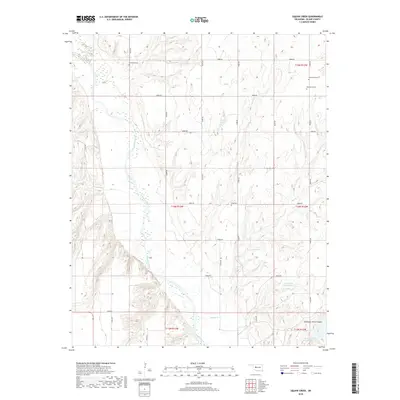
2018 Map of American Horse Lake
USGS Topo · Published 2018About this map
The Canadian River meanders across this rural landscape in central Blaine County, carving a wide path through the Oklahoma terrain. The map area is defined by its water systems and deep topographical features like American Horse Canyon, which leads into the prominent American Horse Lake in the southeast corner. This region maintains a strong connection to its early 20th-century history through several well-preserved burial grounds, including Whirlwind Cem, Emmanuel Cem, Macedonia Cem, and Etna Cem, which are scattered among the section lines and drainage basins of Squaw Cr and Bear Cr. The structured grid of section roads, such as e0900 RD and e0920 RD, provides a window into the organized land distribution that shaped this agricultural and ranching territory. Smaller water features like Groendyke Pond Number 1 indicate localized land management and the importance of water storage in this prairie environment.
Find a feature on this map
22 named features on this map. Tap any name to fly to it.
Don’t see what you’re looking for? This feature index may not catch every label — zoom into the map to look around manually.
Map Details
Editions of this 2018 American Horse Lake Map
This is the sole edition of this map. No revisions or reprints were ever made.
Other maps of this area

1942 · Geary
USGS Topo · 1:62,500

1955 · Clinton
USGS Topo · 1:250,000

1957 · Clinton
USGS Topo · 1:250,000

1964 · Oakwood
USGS Topo · 1:62,500

1964 · Weatherford
USGS Topo · 1:62,500

1972 · Watonga
USGS Topo · 1:24,000

1979 · Greenfield
USGS Topo · 1:24,000
1979 · Bridgeport
USGS Topo · 1:24,000
1985 · Weatherford
USGS Topo · 1:24,000
1985 · Hydro
USGS Topo · 1:24,000